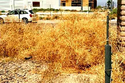
Cal. 86 and Junction S-22 Imperial County at Salton City, mustard plants caught in a 4 foot tall highway cyclone fence, forming a ramp that allows other plants to jump the fence. Photo 5/18/05
Intellectual Property Notice: You are welcome
to reprint this data, for your own personal use. However, if you
want to distribute, reproduce, modify or incorporate this data
into another product including maps, you need to obtain a license
for use. Craig Dremann owns the title, copyright, and other intellectual
propertiy rights on this data, and the data is licensed, not sold.
Reprinting the data or utilizing it for economic purposes including
projects funded by grants, without obtaining a license, the user
agrees to pay liquidated damages of $100 per mile. Use of this
web site constitutes your acceptance of this agreement, and Craig
Dremann reserves the right to change the terms and conditions
under which it offers this site. - Licenses are available
for use of the data by researchers, universities, or agencies
at $8 per mile.
PICTURES
Cal. 86 and Junction S-22 Imperial County at Salton City, mustard
plants caught in a 4 foot tall highway cyclone fence, forming
a ramp that allows other plants to jump the fence. Photo 5/18/05
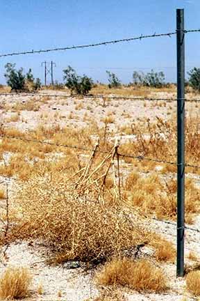
Cal. 86 PM 46 Imperial County tumbling mustard stuck on fence,
trying to get into nice creosote bush habitat. Photo. 5/18/2005.
California Highway 86 & 86-S - May 2005 - Raw data.
Results of a 70 mph windshield survey (or whatever the local
speed limits were), of Sahara Mustard (Brassica tournefortii):
Either not present; is present along roadsides or in medians;
or is outside of the roadside to the fence line or has moved from
the roadsides to infest adjacent land.
NS = No Sahara mustard was seen along roadside
ditches; or if divided highway, also not seen in the roadside
median, or in lands adjacent to the road.
RS = Road Sides were infested with Sahara mustard. MED = In divided highways, in medians.
DES = Sahara mustard has moved from the roadsides into the desert, agricultural areas, or other lands adjacent to the roadsides. FL or Fences = Only found along the highway cyclone-fence line, but is far enough off the roadside to pose an immediate problem for the lands adjacent to the fences. At the time of the survey, did not appear to be moving off the fence line yet.
SPECIES SURVEYED for:
BT = Brassica tournefortii or Sahara Mustard
PM = Post miles along highways, and numbers indicate the
averages found not just at each post mile, but for 1/2 mile on
either side of the post mile marker.
(Landmarks and other notes on other exotics or native plants will
be in parentheses)
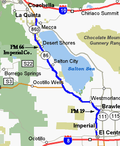
IMPERIAL COUNTY, from Junction Interstate 8, northbound and
west
Survey 5/17/2005, notebook 193, page 46 & 5/18, notebook
194, pages 6-8
0-1 - NS
- City of El Centro
1 - NS - city
2 - NS - city
3 - NS - city
4 - NS - city
5 - NS - city
6 - NS - city
7 - NS - city
8 - NS - city
9 - NS - End
of City of El Centro
10 - NS - agricultural lands (County Road S-28)
11 - NS - agricultural lands
12 - NS - agricultural lands
13 - NS - agricultural lands
14 - NS - agricultural lands
15 - NS - agricultural lands
16 - NS - agricultural lands
17 - NS - agricultural lands
18 - NS - agricultural lands
19 - NS -
City of Brawley
20 - NS
21 - NS
22 - NS -
City of Brawley
New River
23 - RS - very rare, only one plant
24 - NS - agricultural lands
25 - NS - agricultural lands
26 - NS - agricultural lands
27 - NS - Town
of Westmoreland
28 - NS
29 - NS - agricultural lands
30 - NS - agricultural lands
31 - NS - agricultural lands
32 - NS - agricultural lands
33 - NS - agricultural lands
34 - NS - agricultural lands
35 - NS - agricultural lands
36 - DES - scattered
37 - DES within 10 feet of road but
not along roadsides
38 - DES within 10 feet of road but
not along roadsides
39 - DES thick in places, RS and
median scattered - Willow Wash
40 - DES scattered
41 - DES rare
42 - DES rare
43 - DES scattered
Inspection Station for Immigration
44 - RS solid in places
45 - RS along fences, plants caught,
keeping plants from going out into desert
46 - RS solid along fence
47 - RS and median scattered
48 - DES scattered, spreading out
one mile from road
49 - DES scattered, spreading out
one mile from road
50 - RS occasional in median
51 - RS caught in fences
52 - RS fences and occasional in
median
53 - RS fences and occasional in
median
54 - RS fences scattered (Surprise Wash)
55 - RS - fences rare
56 - RS along fences (Salton City)
57 - DES solid towards Salton Sea
58 - DES scattered, RS along fences
59 - DES rare, RS along fences
60 - DES rare, RS along fences
61 - DES scattered, RS along fences
62 - DES scattered, RS along fences
63 - DES scattered, RS along fences
64 - RS fences
65 - DES scattered, RS fences
66 - DES scattered, RS fences solid
- Town of Desert Shores
67 - DES scattered
67.80 Imperial/Riverside county line
RIVERSIDE COUNTY, westbound
0-1 - RS
and Median thick, ag. lands outside of roadway
1 - RS and Median thick, ag. lands
outside of roadway
2 - RS and Median thick, ag. lands
outside of roadway
Cal. 86 & 86S split, continue up 86S, a new highway
3 - NS
4 - NS - saline soils
5 - NS - saline soils
6 - NS - saline soils, dates
7 - NS - saline soils
8 - NS - saline soils
9 - NS - saline soils
10 - NS - saline soils, dates
11 - NS - saline soils
Junction of Cal. Hwy. 111, and road
to town of Mecca
Updated April 21, 2016. Back to Craig Dremann's main Contents page.