Intellectual Property Notice: You are welcome
to reprint this data, for your own personal use. However, if you
want to distribute, reproduce, modify or incorporate this data
into another product including maps, you need to obtain a license
for use. Craig Dremann owns the title, copyright, and other intellectual
propertiy rights on this data, and the data is licensed, not sold.
Reprinting the data or utilizing it for economic purposes including
projects funded by grants, without obtaining a license, the user
agrees to pay liquidated damages of $100 per mile. Use of this
web site constitutes your acceptance of this agreement, and Craig
Dremann reserves the right to change the terms and conditions
under which it offers this site. - Licenses are available
for use of the data by researchers, universities, or agencies
at $8 per mile.
Cal. Hwy 14 - March-April
2005 - Raw data.
Results of a 70 mph windshield survey (or whatever the local speed
limits were), of three exotic Mustards: Either not present; is
present along roadsides or in medians; or is outside of the roadside
to the fence line or has moved from the roadsides to infest adjacent
land.
NS = None Seen. None of the three exotic
Mustards of concern were seen along roadside ditches; or if divided
highway, also not seen in the roadside median, or in lands adjacent
to the road.
RS = Road Sides were infested. MED = In divided highways, in medians.
DES = One or more Exotic Mustards have moved from the roadsides into the desert, agricultural areas, or other lands adjacent to the roadsides.
SPECIES PRESENT:
BT = Brassica tournefortii = Sahara Mustard
SL = Sisymbrium irio = London Rocket
SO = Sisymbrium orientale = Indian Hedge Mustard
PM = Post miles along highways, and numbers indicate the
averages found not just at each post mile, but for 1/2 mile on
either side of the post mile marker.
(Landmarks and other notes on other exotics or native plants will
be in parentheses)
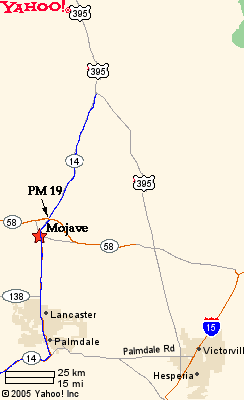
KERN COUNTY, Cal. Hwy 14 , Junction of
Cal. Hwy 58, north to Cal. 178
Raw data March 20, 2005, updated April 4.
Start Kern County/Los Angeles County line, survey moving northward
0 = Kern County/Los Angeles County
line
0-1 - NS - (Four lanes)
2 - NS
3 - NS - Rosemont exit
4 - NS
5 - NS (Native grasses)
6 - NS (Joshua tree forest and native grasses - Dawn Road)
7 - NS (Joshua tree forest)
8 - Median - SL rare
9 - Cloverleaf - SL present (Backus Road)
10 - RS - SL scattered (Native grasses present)
11 - RS - SL & SO scattered
12 - NS (Inidan ricegrass in median)
13 - RS - SL rare (cross traffic starts)
14 - NS (4 lanes, highway runs along
railroad tracks)
15 - NS (Railroad bridge overpass and town starts)
16 - DES - SL (Town of Mojave). Goes to 2 lanes at PM 16.2
17 - RS - SO scattered
18 - RS - SO scattered. 4 Lanes start, Silymbium mustard as a
contaminant in wheat straw used for erosion control for new Cal.
58 construction.
19 - RS - SO
20 - NS (Indian Ricegrass common)
21 - RS - BT - scattered (Junction
California City exit)
22 - NS (Amsinckia)
23 - NS
24 - RS - BT
25 - NS
26 - NS
27 - NS
28 - MED - BT
29 - NS
30 - MED - BT scattered
31 - MED - BT
32 - MED - BT
33 - MED - BT
34 - MED - BT
35 - DES - BT
(Jawbone Canyon. wash, the BLM ORV
area infestation)
36 - RS - BT
37 - RS - BT
38 - NS
39 - RS - BT - rare
40 - RS - BT - rare
41 - RS - BT - scattered
42 - RS - BT - rare (Divided road)
43 - NS
44 - NS (Amsinckia)
45 - NS (Amsinckia)
46 - NS (Amsinckia and solid Goldfields in desert)
47 - NS
48 - NS
49 - NS
50 - NS (Indian ricegrass = roadside colonizer)
51 - NS (solid Amsinckia)
52 - NS (solid Amsinckia)
53 - NS (solid Amsinckia, Desert stipa)
Robber's Roost
54 - NS (Indian ricegrass, Amsinckia, Desert stipa)
55 - NS (Desert dandelion)
56 - NS
57 - RS - BT - rare, scattered
58 - NS
59 - NS (Amsinckia)
60 - NS
61 - NS (Elev. 3,000 feet at PM 60.50)
62 - NS (Junction 178 east - Native Poa and 4 lanes starts Encelia)
63 - NS (Solid Encelia)
64 - NS (Solid Encelia)
65 - NS - Junction with US 395
Cal 14, south Kern County/Los
Angeles County line, survey moving southward
77.01 = starts at Los Angeles
County
77 - Median - SO scattered
76 - RS - SO scattered (Avenue A)
75 - RS & Median - SO
74 - RS & Median - SO (Junction
138- 4 lanes)
73 - RS & Median - SO (Avenue
E)
72 - RS & Median - SO thick (Avenue
F)
71 - Median - SO (Avenue G)
70 - RS - SO (Avenue H)
69 - NS (Avenue
I - City Lancaster)
68 - NS
(Avenue J - City Lancaster)
67 - NS - City
66 - RS - SL scattered
65 - NS (Avenue
M - City Palmdale)
64 - NS (Desert
stipa common)
63 - RS - SL common (Avenue N)
62 - RS - SL scattered (Avenue O)
61 - NS
(City of Palmdale)
60 - RS - SL scattered (also Calif. poppy)
59 - RS - SL thick in places
58 - RS - SL scattered
57 - NS (Calif.
aquaduct, Desert stipa and native Poa)
56 - NS
(Wild oats start, native poa)
55 - NS
54 - NS (California poppies)
53 - NS
52 - NS (California poppies, Amsinckia)
51 - NS
50 - NS
49 - NS
48 - NS
47 - NS
46 - NS
45 - RS - BT! (only location for 40 miles, solid stand only
a few square feet)
Updated April 20, 2016. Back to Craig Dremann's main Contents page.