2005 Arizona
Saharan Mustard Roadside Survey
Interstate 40 - Arizona - September 2005 - Raw data.
Surveyed and Copyright © 2005
by Craig Dremann
Box 361, Redwood City, CA 94064
- (650) 325-7333
Intellectual Property Notice: You are welcome
to reprint this data, for your own personal use. However, if you
want to distribute, reproduce, modify or incorporate this data
into another product including maps, you need to obtain a license
for use. Craig Dremann owns the title, copyright, and other intellectual
property rights on this data, and the data is licensed, not sold.
Reprinting the data or utilizing it for economic purposes including
projects funded by grants, without obtaining a license, the user
agrees to pay liquidated damages of $100 per mile. Use of this
web site constitutes your acceptance of this agreement, and Craig
Dremann reserves the right to change the terms and conditions
under which it offers this site. - Licenses are available
for use of the data by researchers, universities, or agencies
at $10 per mile.
Pictures
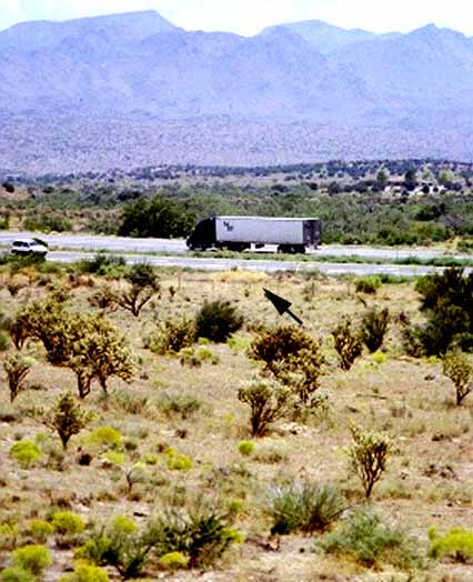 I-40 Arizona, the infestation just getting started
along roadside, at US 93 southbound to Phoenix, PM 71.
I-40 Arizona, the infestation just getting started
along roadside, at US 93 southbound to Phoenix, PM 71.
You can see how much potentially vulnerable desert is in the area?
Arrow points to Sahara mustard stand, about the dimensions of
an automobile in September, 2005.
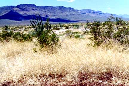 Rest stop I-40 PM 23 near Yucca Arizona, between Kingman
and Needles. Photo from westbound rest stop, looking west. The
density of the mustard takes your breath away, swallowing the
desert alive!
Rest stop I-40 PM 23 near Yucca Arizona, between Kingman
and Needles. Photo from westbound rest stop, looking west. The
density of the mustard takes your breath away, swallowing the
desert alive!
Interstate 40 Arizona
- September 2005 - Raw data.
Results of a 70 mph windshield survey (or whatever the local
speed limits were) for Sahara Mustard (Brassica tournefortii).
Either not present; is present along roadsides or in medians;
or is outside of the roadside to the fence line or has moved from
the roadsides to infest adjacent land.
NS = No Sahara mustard was seen along roadside
ditches; or if divided highway, also not seen in the roadside
median, or in lands adjacent to the road.
RS = Road Sides were infested with
Sahara mustard. MED = In divided highways, in medians.
DES = Sahara mustard has moved from
the roadsides into the desert, agricultural areas, or other lands
adjacent to the roadsides. FL = Only found along the highway cyclone-fence
line, but is far enough off the roadside to pose an immediate
problem for the lands adjacent to the fences. At the time of the
survey, did not appear to be moving off the fence line yet.
SPECIES SURVEYED for:
BT = Brassica tournefortii or Sahara Mustard.
PM = Post miles along highways, and numbers indicate the
averages found not just at each post mile, but for 1/2 mile on
either side of the post mile marker.
(Landmarks and other notes on other exotics or native plants will
be in parentheses)
ARIZONA I-40, starts at California border
Survey September 4, 2005 - Notebook 197, pages 25-31
(Post Miles)
0-1 - NS -
riparian - town of Toprock
1 - DES 50 feet out, in badlands
washes
2 - DES solid out 3-5 miles north
3 - DES solid out 3-5 miles north
4 - DES scattered in washes, badlands
- Highway truck weigh station
5 - DES solid out 1/4 mile in places
6 - DES scattered out 1/4 mile
7 - DES solid out 1/2 mile
8 - DES scattered out 1/2 mile
9 - DES scattered out 1/2 mile
10 - DES scattered out 1/2 mile
11 - DES scattered out 1/2 mile
12 - DES solid out 1/2 mile
13 - DES solid out 1/2 miles, to
railroad tracks
14 - DES scattered out 1/2 mile
15 - DES scattered out 1 mile
16 - DES solid out 1 mile
17 - DES scattered out 1/2 mile
18 - DES scattered out 1/2 mile
19 - DES solid out 1/2 mile
20 - DES scattered out 1/2 miles
21 - DES scattered out 1 miles and
up the side of volcanics
22 - DES scattered out 1/2 mile
23 - DES scattered out 2 miles
24 - DES scattered out 1/4 mile
25 - DES scattered out 1/4 mile
26 - DES scattered -
town of Yucca
27 - DES scattered out 1/2 mile
28 - DES scattered out 1/2 mile
29 - DES scattered out 1 mile
30 - DES scattered out 2 miles
31 - DES scattered out 1/2 mile
32 - DES scattered out 1/2 mile
33 - DES scattered out 1 mile
34 - DES scattered out 1 mile
35 - DES scattered out 1/4 mile
36 - DES scattered out 1 mile
37 - DES scattered out 1 mile
38 - DES scattered out 2 miles
39 - DES scattered out 2 miles
40 - DES scattered out 2 miles then
stops at wash
41 - DES solid out 1/2 mile
42 - DES solid out 1/2 mile and solid
along railroad tracks
43 - DES solid out 1/2 mile
44 - DES solid out 1/2 mile
45 - DES solid out 1/2 mile
46 - DES out 100 feet, and RS
47 - DES out 100 feet, and RS
48 - NS
49 - NS -
US 93 north exit
50 - NS
51 - NS -
town of Kingman
52 - NS -
town of Kingman
53 - NS -
town of Kingman
54 - NS -
town of Kingman
55 - NS -
desert grasslands
56 - NS -
desert grasslands
57 - NS -
desert grasslands
58 - NS -
desert grasslands
59 - NS -
desert grasslands
60 - NS -
desert grasslands
61 - NS -
desert grasslands
62 - NS -
desert grasslands
63 - NS -
desert grasslands
64 - NS -
desert grasslands
65 - NS -
desert grasslands
66 - NS -
desert grasslands
67 - NS -
desert grasslands
68 - NS -
desert grasslands
69 - NS -
desert grasslands
70 - NS -
desert grasslands
71 - RS scattered
72 - Junction US 93
73 - NS
74 - NS
75 - NS
76 - NS
77 - NS
78 - NS
79 - NS
80 - NS -
elevation 5,000 feet
81 - NS -
desert ends
82 - NS
83 - NS
84 - NS
85 - NS
86 - NS
87 - NS -
juniper grasslands
88 - NS - Elev. 5,000 ft.- the potential eastern edge for the
Sahara mustard
89 - NS
90 - NS
91 - NS -
Fort Rock Road
92 - NS
93 - NS
94 - NS -
grasslands with junipers
95 - NS
96 - NS
97 - NS
98 - NS
99 - NS
100 - NS
101 - NS
102 - NS
103 - NS
104 - NS
105 - NS
- grasslands with rabbitbrush
106 - NS
107 - NS
108 - NS
109 - NS
110 - NS
111 - NS
112 - NS
113 - NS
114 - NS -
junipers
115 - NS
116 - NS
117 - NS
118 - NS
119 - NS -
grasslands, rabbitbrush thick
120 - NS
121 - NS
122 - NS -
Seligman
123 - NS
124 - NS
125 - NS
126 - NS
127 - NS
128 - NS
129 - NS
130 - NS
131 - NS -
junipers
132 - NS
- volcanics end
133 - NS
134 - NS
135 - NS
136 - NS -
Indian ricegrass ends, grasslands
137 - NS
138 - NS
139 - NS
140 - NS
141 - NS
142 - NS
143 - NS
144 - NS
145 - NS
146 - NS -
Ash Fork, elev. 5144
147 - NS -
scattered juniper in grasslands, rabbitbrush
148 - NS
149 - NS
150 - NS
151 - NS
152 - NS
153 - NS
154 - NS
155 - NS
156 - NS
157 - NS
158 - NS
159 - NS
- junipers end
160 - NS
161 - NS -
Williams exit
162 - NS
163 - NS
164 - NS
Town of Williams exit
165 - NS
166 - NS
167 - NS
168 - NS
169 - NS
170 - NS -
rapid increase in rainfall from this point eastward, piney wood
start
171 - NS
172 - NS -
Pittman Valley Road
173 - NS
174 - NS
175 - NS
176 - NS
177 - NS
178 - NS
179 - NS
180 - NS
181 - NS
182 - NS - Rest
stop
183 - NS
184 - NS
185 - NS
186 - NS
187 - NS
188 - NS
189 - NS
189 - NS
190 - NS -
Elev. 7300 divide
191 - NS
192 - NS
193 - NS
194 - NS
195 - NS
196 - NS -
Junction 1-17
197 - NS
198 - NS
199 - NS
200 - NS
201 - NS
End at City of Flagstaff, Junction of US 89
Updated December 24, 2022 - The
Reveg Edge Ecological Restoration service
- BACK TO MAIN MUSTARD PAGE