Intellectual Property Notice: You are welcome
to reprint this data, for your own personal use. However, if you
want to distribute, reproduce, modify or incorporate this data
into another product including maps, you need to obtain a license
for use. Craig Dremann owns the title, copyright, and other intellectual
propertiy rights on this data, and the data is licensed, not sold.
Reprinting the data or utilizing it for economic purposes including
projects funded by grants, without obtaining a license, the user
agrees to pay liquidated damages of $100 per mile. Use of this
web site constitutes your acceptance of this agreement, and Craig
Dremann reserves the right to change the terms and conditions
under which it offers this site. - Licenses are available
for use of the data by researchers, universities, or agencies
at $8 per mile.
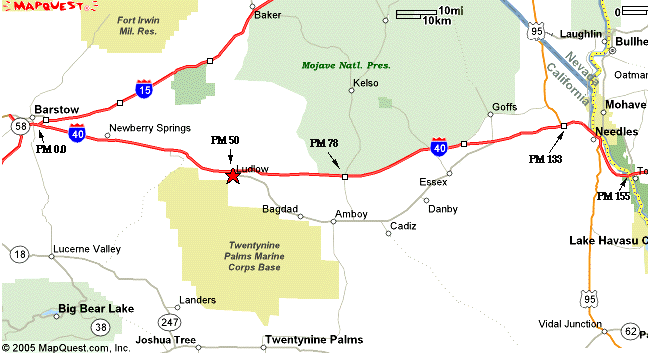
I-40 at PM 42, 8 miles west of Ludlow, mustard out into the
desert for 1-2 miles solidly.
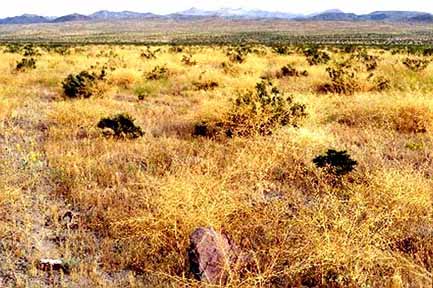
I-40 San Bernardino County PM 55, 5 miles east of Ludlow, solid
out into the desert.
I-40 PM 50, Saharan mustard at Ludlow, thick along the roadsides.
May 16, 2005.
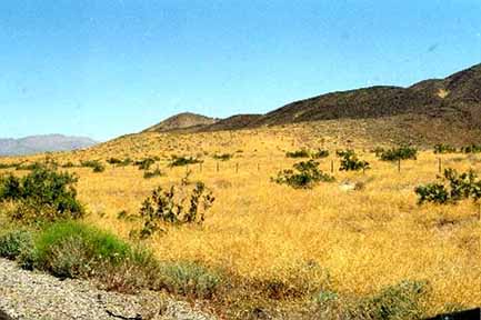
I-40 Rest Stop near Essex, Saharan mustard just getting started,
with desert still unmolested.
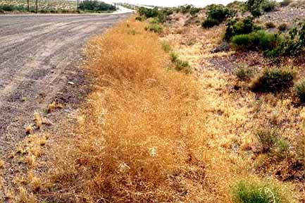
I-40 in the town of Needles, mustard solidly along the roadside.
May 16, 2005.
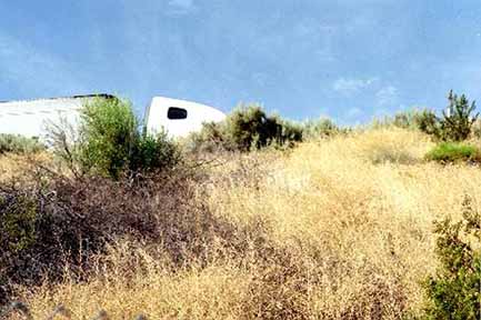
Vicinity of I-40 and desert around the town of Needles, Saharan mustard thick in the desert. Five Miles Road exit, San Bernardino County PM 148.
Interstate 40 - May
2005 - Raw data.
Results of a 70 mph windshield survey (or whatever the local
speed limits were) for Saharan Mustard (Brassica tournefortii).
Either not present; is present along roadsides or in medians;
or is outside of the roadside to the fence line or has moved from
the roadsides to infest adjacent land.
NS = No Sahara mustard was seen along roadside
ditches; or if divided highway, also not seen in the roadside
median, or in lands adjacent to the road.
RS = Road Sides were infested with Sahara mustard. MED = In divided highways, in medians.
DES = Sahara mustard has moved from the roadsides into the desert, agricultural areas, or other lands adjacent to the roadsides. FL = Only found along the highway cyclone-fence line, but is far enough off the roadside to pose an immediate problem for the lands adjacent to the fences. At the time of the survey, did not appear to be moving off the fence line yet.
SPECIES SURVEYED for:
BT = Brassica tournefortii or Sahara Mustard.
PM = Post miles along highways, and numbers indicate the
averages found not just at each post mile, but for 1/2 mile on
either side of the post mile marker.
(Landmarks and other notes on other exotics or native plants will
be in parentheses)
SAN BERNARDINO COUNTY, start at Junction I-15, Barstow, California.
Survey 5/16/2005 - Data to follow later, notebook 193, pages 22-23, 25-33.
(Post Miles)
0-1 - RS and MED, scattered - town of Barstow, California
1 - RS - scattered
2 - RS scattered, thick in places -
Marine Corps. Logistics Base exit
3 - RS - solid
4 - Rs solid- Nebo Road
5 - DES, RS, plants just starting
to escape the roadsides
6 - DES & RS
7 - DES & RS - Daggett exit
8 - DES & RS, solid between road
and river
9 - DES & RS, scattered
10 - RS, scattered
11 - DES scattered
12 - RS & Med scattered - Barstow-Daggett airport exit
13 - MED scattered
14 - RS & MED scattered
15 - RS rare
16 - NS - good native area
17 - NS - good native area
18 - NS - good native area
Newberry Springs Road exit
19 - NS - saline playa and wash
20 - NS alkaline
21 - NS wildflowers, compositae
22 - NS
23 - NS - Fort Cody Road exit
24 - NS
25 - NS
26 - NS - playa, solid wildflowers
around the edges.
27 - NS
28 - NS - (Rest Stop)
29 - NS - Goldfields
and lava beds
30 - NS - Lava
beds
31 - NS
32 - NS - wildflowers
Hector Road, Old US 66
33 - NS -
wildflowers
34 - MED -
thick in places
35 - DES and RS scattered
36 - DES and RS thick in places
37 - DES solid, EVEN IN LAVA!
38 - RS and MED thick, solid - Railroad overcrossing
39 - DES, MED and RS, thick, spreading
solidly off road
40 - DES solid off road
41 - DES solid off road
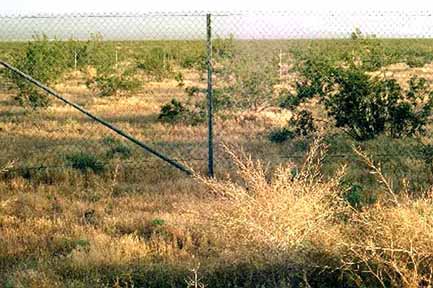
42 - DES solid out one mile in each direction
43 - DES solid out one mile in each direction
44 - DES solid out one mile in each direction
45 - RS and MED solid
46 - DES scattered
47 - DES scattered, thick in places
48 - DES scattered, thick in places
49 - DES scattered, thick in places
50 - RS scattered -
Ludlow exit
51 - DES scattered
52 - RS and MED scattered
53 - RS and MED scattered
54 - DES up SOLID VOLCANICS!
55 - DES solid for 1/4 to one mile
56 - DES solid for 1/2 mile
57 - DES scattered
58 - NS -
volcanics
59 - NS
60 - NS
61 - NS
62 - NS
63 - NS
64 - NS
65 - NS
66 - NS
67 - NS
68 - NS
69 - RS and MED scattered
70 - RS and MED scattered
71 - RS and MED scattered
72 - MED rare
73 - MED rare
74 - NS
75 - DES and MED scattered
76 - DES and MED scattered
77 - DES and MED scattered
78 - MED rare to scattered - Kelbaker Road exit
79 - NS
80 - NS
81 - NS
82 - NS
83 - RS and MED scattered
84 - MED rare
85 - NS
86 - NS
87 - MED rare
88 - MED rare
89 - RS and MED rare
90 - RS and MED rare
91 - NS
92 - NS
93 - MED rare
94 - RS very rare, only one plant
95 - MED very rare
96 - NS
97 - NS
98 - NS
99 - NS
100 - MED scattered - Essex Road
101 - MED scattered
102 - RS and MED scattered
103 - RS and MED scattered
104 - RS and MED scattered
105 - RS and MED scattered
Rest Stop - PM 105.5
Goffs Road
106 - DES out one mile
107 - DES out one mile
108 - DES scattered
109 - RS and MED scattered
110 - RS and MED scattered
111 - RS and MED scattered
112 - RS and MED thick in places
113 - MED, thick in places
114 - MED scattered
115 - MED rare
116 - MED very rare
117 - MED very rare
118 - MED very rare < 20 plants per mile
119 - MED very rare
120 - MED very rare - Water Road
121 - DES solid out 1/4 mile
122 - DES scattered
123 - NS
124 - MED rare
125 - NS chola garden in hills
Summit
126 - NS
126 - NS - chollas
127 - NS - dwarf creosotes
128 - NS
129 - NS
130 - MED rare
131 - NS
132 - MED rare
133 - RS and MED scattered - US 95
North exit
134 - RS and MED rare
135 - RS and MED rare
136 - RS and MED scattered
137 - DES scattered
138 - DES scattered
139 - DES scattered - River Road
Cutoff exit
140 - RS and MED scattered
141 - DES scattered - Needles, West Broadway exit
142 - RS and MED solid, town of Needles, J Street exit
143 - DES scattered, town of Needles, US 95 South exit
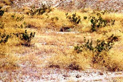
144 - DES thick
145 - DES thick
146 - DES thick and under every creosote
147 - DES thick and under every creosote
148 - DES thick and under every creosote - Five Mile Road exit
149 - DES thick and under every creosote
150 - DES thick and under every creosote, solid in washes
151 - DES thick and under every creosote
152 - NS, hills
153 - NS - Park Moabi exit
154 - NS
155 - (Colorado River)
End Colorado River, Arizona Border.
Updated December 24, 2022 - The
Reveg Edge Ecological Restoration service